
The location of an earlier church at Church Knoll, suggested in the first instance by the place name, is supported by the convergence of many roads and footpaths on the large area of common land adjacent to the knoll. Further support is given by the fact that, until c,1840, the 350 yard stretch of the present main road between The Crown and the former manor house at Penbury Farm, did not exist. A journey from Penn to Beaconsfield, before 1840, would have taken you down Crown Lane, The earlier direct road link was between the manor house and Church Knoll. (See sketch map).
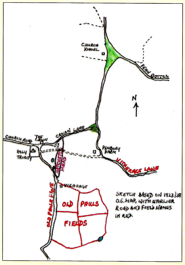
Local folk lore has the church being moved uphill, stone by stone, despite the devil’s best efforts to prevent it, and our church very probably does rest on sarsen stones from Church Knoll, which is itself the result of a natural accumulation of stones after the ice age. The church at Church Knoll was almost certainly of wood and very unlikely to have had its own graveyard since burials would have been at Taplow, then our mother church. In 1177, according to the date on a foundation stone reported by a reliable earlier vicar, the new church was built. It was sited precisely on the highest spot of ground closest to the manor house, to which it was linked by a track, still a footpath, that comes out between the cottages on Pauls Hill and heads for the south porch door,
Whereas Saxon churchyards were usually roughly circular, the Normans introduced a rectangular form, usually of one customary acre. A medieval acre varied considerably from place to place, but I have concluded from other researches that Penn’s medieval acre was not much different from today’s standard acre (4,840 sq yds), In fact, our churchyard, after removing a 1904 addition on the western boundary, is very close to both a rectangle and a standard acre.
The church’s position was decided by the highest ground, but it is also very precisely in the middle of the N-S axis of the churchyard, This seems more likely to have been deliberate than fortuitous, and suggests that the churchyard was drawn around the church, after the church was built, and therefore that the present lines of both Church Road and Pauls Hill were decided by the churchyard boundary, This suggestion is borne out by the sudden jink of Pauls Hill at the entrance to the former vicarage, away from the direction of Crown Lane and Church Knoll and towards the new church boundary, Its earlier route could be marked by an unusually long and narrow field with ponds, which was called Hatchetts Mead in 1838,
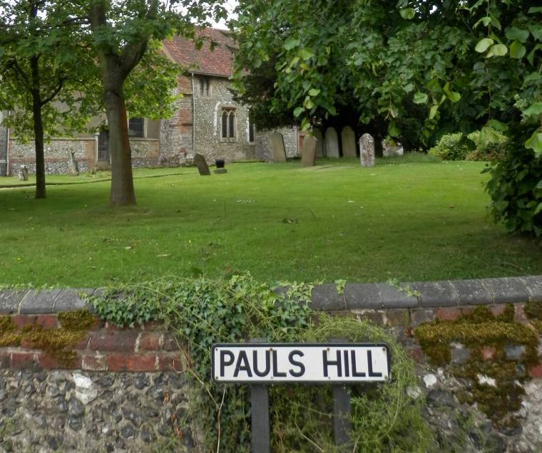 Pauls Hill was called Old Pauls Lane on the 1855 Inclosure map, and a farm and four field names below the former vicarage were called Old Pauls on the 1838 Tithe map, This all fuels my belief that our church was dedicated to St Paul before it was rededicated, as often happened after a major rebuilding, to the Holy Trinity, perhaps in the early 14th century after the tower and south aisle had been added, or a century later when the new roof was put on, Chacombe Priory, then Penn’s proprietor, was dedicated to St Peter and St Paul. The earliest reference to Holy Trinity noted so far is in a will of 1505, The earlier name for Pauls Hill could well have been Gatemoor Hill, a name shown on older maps and still borne by a former common, a wood and a field at the bottom of the hill.
The drawing of the churchyard boundary to put the church at its western edge, may well have been deliberate to permit more space for burials around the chancel, the holiest part of the church, The normal prejudice against the north as the devil’s side, did not seem to have been very strong, because although there have been visibly more burials to the south, the favoured sunny side where every medieval church had a tall churchyard cross, two important graves lined with 14th century Penn tiles were found immediately outside the north porch door in 1967, The north was also the village side, which would have made it less threatening.
© Miles Green, October 2005